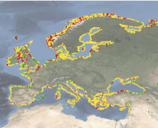
The shoreline is a highly dynamic land-sea interface that provides important services such as ecology, flood protection and recreation. It is constantly modified by wind, waves and tides, and impacted by human activity.Hence, the decadal change of shorelines reflect natural processes as well as human influence, whether positive or negative. Climatic-driven changes such as sea level rise, higher waves and changes in wind direction put increasing pressure on many of Europe’s shorelines. Knowing how, and at what rate, our coasts are changing is the first step to successfully managing them. The new EMODnet Geology shoreline-migration map, released today, allows users to visualise pan-European coastal behaviour for 2007-2017 at different spatial scales. A built-in search and zoom functionality allows online users to distinguish areas of landward migration (erosion or submergence), stability, and seaward migration (accretion or emergence). The underlying, downloadable satellite-based dataset offers additional information on annual values and uncertainty. Click here to view/download the...
EGS Strategy and need for European geoscientific data and knowledge in EU policy developments
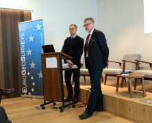
posted by EuroGeoSurveys
EuroGeoSurveys President, Dr. Zdenek Venera, opened the EGS Directors Workshop on the need for European geoscientific data and knowledge in EU policy developments and the EGS strategy explaining how the National Geological Surveys, members of EuroGeoSurveys (EGS), are public sector institutions carrying out operations and research in the field of geosciences, with a long tradition in collecting data, preparing information and conducting research focused on their national subsurface. Besides their national mandates, EGS members play an important role in EU policy developments by providing the European institutions with geoscientific data and knowledge for the benefit of society. Click here to view/ download the...